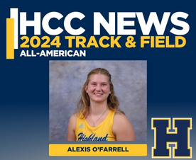
O’Farrell Places 8th at NJCAA National Meet
Alexis O’Farrell (Appleton City, Missouri) placed eighth at the NJCAA Division I national... Read More
This course will provide an introduction to the various careers in agriculture. The course will also cover career and job trends, setting academic goals, note taking, designing a term study plan, preparing for tests, and test taking strategies and skills.
Syllabus • Locations and Class Schedule
This course presents instruction in plant identification, plant health, plant pathology, soil health and crop production. This course covers cropping practices, tillage methods, planting methods and pest control methods with the application of precision agriculture technologies. The course includes hands on experience in tillage, planting and fertilizer/insecticide applications using variable rate application maps.
Syllabus • Locations and Class Schedule
This course focuses on the concepts and procedures used in discovering and applying the spatial relationships within and among maps. It utilizes the mapping and geo-query capabilities of the agricultural Geographic Information System (GIS) platforms to map, analyze, and construct spatial models. This course establishes a comprehensive framework that encompasses a wide range of multi-layered queries, such as: multi-year yield analysis, yield versus field attribute, or fertility versus observed field attribute. The gathering of these layers enables the end-user to design comprehensive models for the analysis of farming operations leading to the development and implementation of improved strategies on the farm or in industry.
Syllabus • Locations and Class Schedule
This course is designed to teach a person with basic electrical knowledge how sophisticated electronic control systems are applied to Precision Agriculture applications. The course will cover simple open-loop control to the more complex closed-loop control systems. The class will introduce a variety of sensors and actuators that are commonly used in conjunction with the controllers, to measure and control various agricultural operations. In addition to control technology, wiring symbols and wiring diagrams will be taught for diagnostics applications.
Syllabus • Locations and Class Schedule
This course provides an overview of precision agriculture concepts and the tools of the discipline: Global Navigation Satellite System (GNSS), Spatial Data Management Platforms, Intelligent Devices, and Implements. Introductory use of each of these tools within the processes of precision agriculture is covered. Hands-on activities with agricultural data and data collection equipment will provide an initial experience in the use of these tools. The primary and secondary economic and environmental benefits to the adoption of these practices are also discussed.
Syllabus • Locations and Class Schedule
This course will prepare the student in the use of various spatial data management platforms. Students will be required to do the initial setup, create management and production lists, save and unload data cards, process field data, and duplicate the process that end-users must do to complete the task of transferring data from the field to the computer. After setting up a data management tree, students will be required to do a field check to ensure that it works to collect and separate the appropriate data. In addition, students will use the software to create reports and prescription maps. Ag Leader® Spatial Management System™ will be the primary platform demonstrated in this course. This will be a project-driven course for which the instructor will provide guidance and the student will be required to read software documentation to complete most of the tasks.
Syllabus • Locations and Class Schedule
This course will prepare the student in the use of various precision farming hardware components. Basic concepts of electricity, electronics, hydraulics, and pneumatics will be covered first. Students will then get hands-on experience in the installation of display modules, guidance units, and control components. This is a project-driven course which requires the students to read and understand technical manuals for the installation. Monitoring and guidance to be demonstrated include Outback® MAX w/A321 RTK, John Deere® GreenStar™ 3 2630 w/StarFire™ 3000 RTK, Case IH® AFS™ 700, Trimble® TMX-2050, Raven® Viper Pro™, and Ag Leader® Integra™
Syllabus • Locations and Class Schedule
This introductory course focuses on the concepts and procedures used in discovering and applying the spatial relationships within and among maps. It utilizes the mapping and geo-query capabilities of the agricultural Geographic Information System (GIS) platform, SST® Summit Professional™, to map, analyze, and construct spatial models. This course establishes a comprehensive framework that encompasses a wide range of multi-layered queries, such as multi-year yield analysis, yield versus field attribute, or fertility versus observed field attribute. The gathering of these layers enables the end-user to design comprehensive models for the analysis of farming operations.
Syllabus • Locations and Class Schedule
This course examines fundamental concepts and theories from the geospatial, cartographic and computing sciences to understand the emergence, use and development of this rapidly growing area of geographic inquiry and research. Focused on GIS, Global Positioning System (GPS) and remote sensing as well as spatial data production, analysis and management, this course combines an in-depth review of the major geospatial theoretical foundations with hands-on practical exercises to offer participants key opportunities to gain knowledge and expertise with which to collect, analyze and produce geospatial and attribute information.
The primary purpose is to demonstrate the various tools available in the industry to assist GIS Specialists, Precision Ag Technicians, Agronomists, and Soil Surveyors in collecting accurate field data. The data will then be interpreted using GIS software to create management zones, grids, and other agronomic research-based decisions. The equipment used in this course will consist of GPS receivers for spatial data, soil collection equipment, GIS platforms for interpretation, and soil contact electrical conductivity sensors.
Syllabus • Locations and Class Schedule
This intermediate course builds upon on the concepts and procedures used in discovering and applying the spatial relationships within and among maps learned in Introduction to Agricultural GIS. It further utilizes the mapping and geo-query capabilities of SST® Summit Professional™ to map, analyze, and construct spatial models while adding the mobile tools found in the SST® Sirrus™ platform. This course re-affirms the comprehensive framework from previous lessons and begins to develop the practical knowledge necessary to succeed in developing and implementing these strategies on the farm or in industry.
Syllabus • Locations and Class Schedule
This course introduces Unmanned Aerial Systems (UAS) platforms, their history, and commercial applications, with special emphasis on Precision Agriculture, Federal Aviation Administration (FAA) regulatory framework, data collection, privacy issues, and navigation concepts. Although instruction will cover content that is needed to pass the certification test for flying drones, no certification will be awarded as part of this class in the actual flight of unmanned aerial vehicles. Further training and instruction will be required for students wishing to acquire and/or pilot aerial vehicles, and students will be responsible for pursuing that certification through testing.
Syllabus • Locations and Class Schedule
The Global Navigation Satellite System (GNSS) is a worldwide, satellite-based navigation system used for aviation, remote sensing, shipping, vehicle tracking, surveying, time transfer, search and rescue operations, and personal communications via satellite. This course provides an introduction to this rapidly growing field, covering both applications and the technology that makes satellite navigation possible. It is by nature an interdisciplinary course, covering subject material in orbit prediction, satellite systems, signal processing, error modeling, computer programming, digital and microwave electronics.
Syllabus • Locations and Class Schedule
The primary goal and function of this capstone course is to assist students in combining the knowledge and skills acquired throughout the program to form a coherent problem-solving resource. The effectiveness of this resource is exhibited in the ability of the student to employ multiple tools found within the discipline to make sound decisions independently in the field. To do this, students will first be exposed to multiple facets of the industry through a multi-lecture series on agribusiness management and strategy. Secondly, to complete the course and the Precision Agriculture curriculum, students will present an original project to an industry panel demonstrating their ability to integrate and communicate their knowledge across the discipline.
Alexis O’Farrell (Appleton City, Missouri) placed eighth at the NJCAA Division I national... Read More

The Highland Community College Board of Trustees approved a new tuition and fee rate of $65 per... Read More